July 29-31, 2018
On our way through Maine to a vow renewal ceremony, we had a few days to explore Acadia National Park for a much-needed respite. We didn’t get to see everything we wanted to, so we will be going back to enjoy more rocky coastline and ocean views from the tops of low granite mountains.
My first impression of Acadia is that it feels a little bit like Oregon. Both places have coniferous trails down to tidal pools. Both have volcanic rocky beaches with chilly windy nights. Both have a lot of lighthouses. Both have amazing access to walks along a cold ocean. They’re different oceans, different flora, different fauna, but the feeling is much the same in both places.
Something that we hadn’t experienced in any park we’ve visited was the free shuttle (fueled with propane) all over Mt. Desert Island (pronounced “dessert”). You can, of course, make a donation to help sustain a cleaner-burning mode of transportation.
Next time we visit, I want to take a bike ride down the carriage road around Eagle Lake. There’s a hike around the lake halfway out. I also really, really want to make a sunrise. Sunup comes early during the Maine summer. We were up at 4 and never could get to a place in time to see it (because we were camped in the trees).
The Ocean Path to Otter Point
Difficulty: Easy
Distance: 2.2 miles
Pros: Incredible ocean and shoreline views, free shuttle to the trailhead
Cons: High traffic trail, mostly beside the road, shuttle wait times during the day
We took a free shuttle to the trailhead at Sand Beach. From Bass Harbor, it was just over an hour and a half travel time. And we got to enjoy the scenery along the way without worrying about the congestion of such a well-visited national park.
Access to the trail started behind the Sand Beach facilities and continued along a gravel path beside the road for a while before we got to Thunder Hole. We got there half an hour before high tide and it was already packed. All along this early part of Ocean Path, there were spurs leading out onto the rocks with views of Sand Beach, The Beehive, and Otter Point. There were also views of islands and ledges, not to mention the bashing waves of the incoming tide against the granite boulders on the shore.

On the way down to Otter Cliffs, the path dipped down through an evergreen forest filled with ferns and mushrooms. There were more spurs to the cliffs along the way, from which you could see Otter Point.

At Otter Point, there was easier access to the waves. They seemed a little milder but still big enough to knock you off balance if you’re not careful. The trail ends at this point, but you can double back to Sand Beach, picking up Otter Cove Trail, Gorham Mountain Trail, or Bowl Trail out to Beehive Trail.

Read about Ocean Path on the Park’s website (opens in a new browser window).
Gorham Mountain via Cadillac Cliffs
Difficulty: Moderate
Distance: 1.7 miles, plus 0.4 of Bowl trail
Pros: Great 360 view of the ocean and mountains from the summit, it’s fun
Cons: Small iron ladder onto Cadillac Cliffs, uneasy footing
The Gorham Mountain trailhead starts near Otter Cliffs, so it was a quick double back of roughly half a mile from Otter Point. It’s blazed with rock cairns and a blue rectangle directly on the path. You might want to train your eyes to look for the blue because there were a couple of times the cairn blended in too well and we missed it.
The challenge of this trail starts immediately when the ferny evergreen forest floor quickly becomes a steep pathway of granite boulders. I’m just under 5’4”, so there was quite a bit of this pathway that I scrambled up or slid down. It’s definitely doable without trekking poles, but they would have made the down parts of the trail a little easier.

Just after you run across what appears to be a sarcophagus for an early trail builder, you can turn to stay on Gorham Mountain Trail or continue up the side of the mountain on Cadillac Cliffs Trail. We turned toward Cadillac Cliffs. This trail starts off straight up and continues that way for some time. There’s a small ladder near the beginning–just two rungs and some hand grips, but it’s a long fall on one side.

Boulder jumping was a huge part of navigating the trail, and sometimes rocks were wobbly when I landed. As a trail runner who almost always jumps on the big rocks ahead of me, I get plenty of practice with sliding and catching my balance. In Kentucky, my practice is on limestone, but this was granite and somewhat slicker dry than what I’m used to. It took a little adjusting.
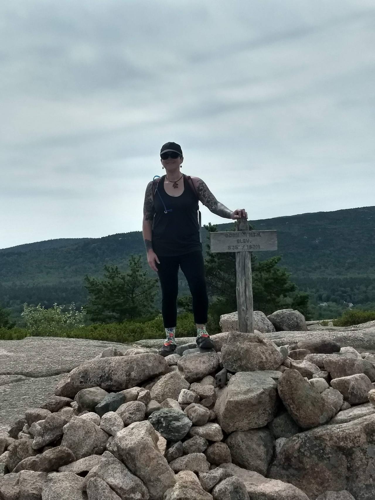
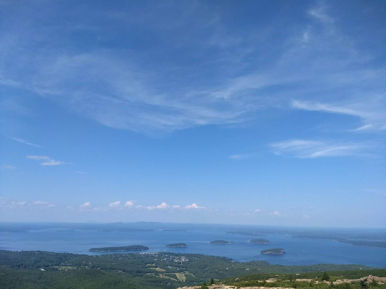
It’s a steep climb to that summit, so take a break and sit to enjoy the 360-degree views of the ocean, many islands, Sand Beach, and all of the surrounding mountains, including Mt. Desert and The Beehive.

The downhill is just like the uphill at the beginning of the trail. It’s steep in parts and sloped in others. About three-quarters of the way across the mountain, you can get a glimpse of Beehive Trail and can watch the hikers climbing up the ladders.
Gorham Mountain Trail ends at Bowl Trail, which curves around the base of The Beehive for half a mile along a stretch of shifty rocks that were much smaller than the boulders from earlier in the trail. If not for my extra grippy trail runners, I might have turned an ankle on this part.
The trail ends across the road from Sand Beach, where you can take a dip in Newport Cove and/or have a picnic, then catch the free shuttle back to wherever you came from on Mt. Desert Island.
Read about Gorham Mountain on the Park’s website (opens in a new browser window).
Cadillac Summit Loop
Difficulty: Easy
Distance: 0.5 miles
Pros: Amazing vistas, easy paved path
Cons: High trail traffic, parking during busy times, not a free island shuttle stop
We took some time to drive up to the summit of Cadillac Mountain, and the views along the way were amazing. There were plenty of pull-offs for overlooks of Jordan Pond and Eagle Lake. There was consistent traffic, but not too bad (it was a weekday).
The parking at the summit, however, was a bit of a challenge. It’s a popular spot for tourist buses if you want to avoid dealing with parking, but the free island shuttle doesn’t go up the mountain. There’s also a visitor center.
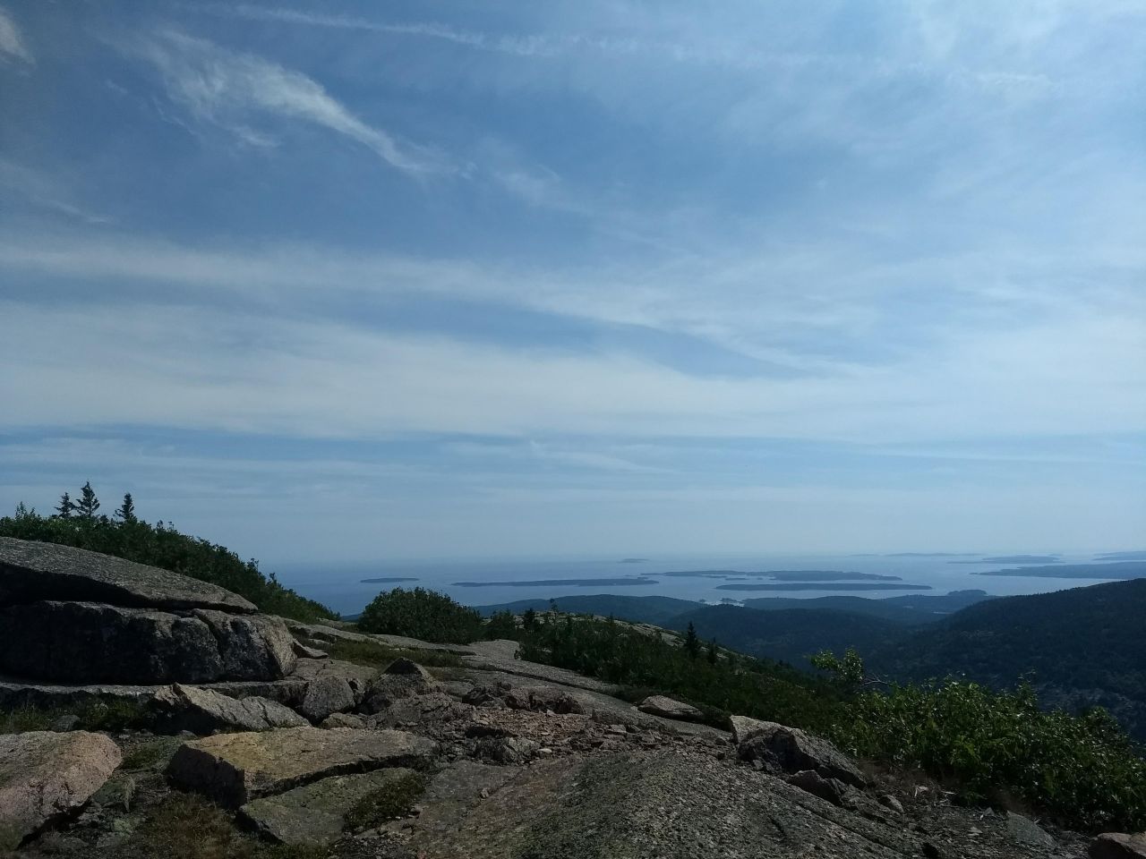
The granite paved path around the Cadillac Mountain Summit is not the highest peak on Cadillac Mountain–that’s on a different trail–but the views couldn’t be better. From the path, you get 360-degree views of the surrounding mountains, lakes, and islands in the Atlantic, as well as Bar Harbor. You can also leave the trail to scramble out closer to the edge of the ridge and get a different view of the valley.
Cadillac Summit Loop is a busy trail, but it’s a large summit so you can still get a little quiet time to enjoy the view if you leave the paved path. Be careful not to step on the scrubby vegetation here, which includes wild blueberries!

From the Cadillac Summit lot, you can also pick up Cadillac North Trail, Cadillac South Trail, Gorge Path, and a number of other trails leading to Mount Desert, Dorr Mountain, Sieur de Monts, and The Gorge. You could spend several days exploring from this one spot.
Read about Cadillac Mountain on the Park’s website (opens in a new browser window).
Seawall
Seawall is literally that, a granite rock wall between the Atlantic Ocean and the shoreline. It came highly recommended by a few locals we asked, especially for the sunrise. We made it a late day activity because of the tide schedule.
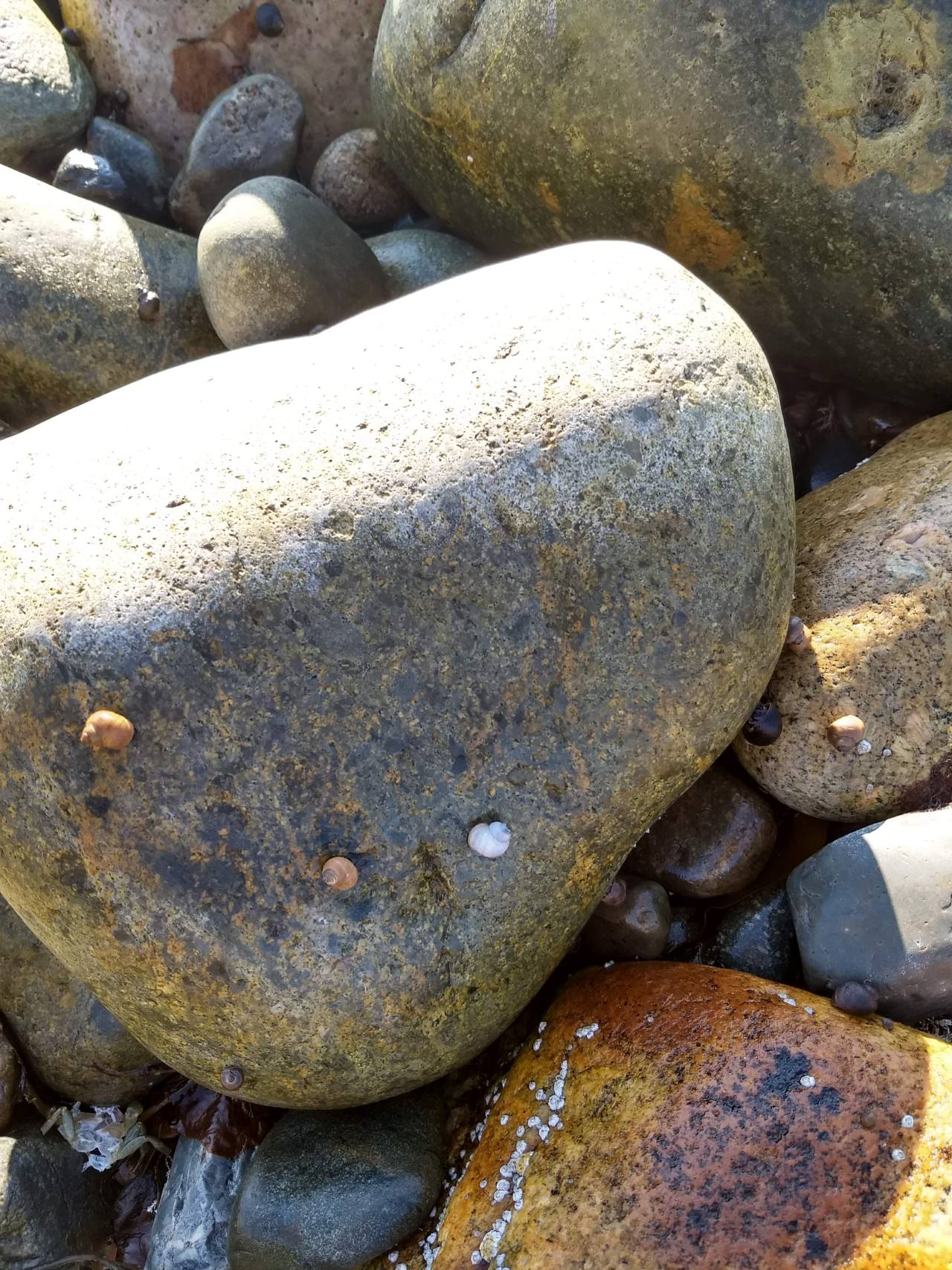
Seawall was close to where we camped, so as the tide was going out, we went to explore some tidal pools. We found a place with plenty of roadside parking. On the inland side of the road was a pond with ducks and the other side was the Atlantic Ocean.

The shoreline is granite rocks and thick lines of seaweed, so it’s a wobbly and sometimes slippery walk out to the water. I dipped my toes in and it was freezing in comparison to the air.

In all the tidal pools, there was an abundance of algae, snails, and barnacles. Plenty of oystercatchers and gulls took advantage of the easy pickins. There’s a great ocean view, with islands in the distance.
You could easily lose a few hours exploring the shore. If you don’t mind sitting on wobbly rocks, it’s a good picnic spot too.
Read more about Seawall at Acadia Magic’s website (opens in a new browser window).


I love Acadia. Thanks for sharing your hikes!
LikeLike
Absolutely! I can’t wait to go back and hike all the trails that we missed during our very short stay.
LikeLiked by 1 person